Region Modifications Details#
On this page:
Overview#
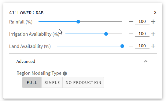
Region modifications are the first step in creating an OpenAg model run and allow for adjustment of region-specific parameters, such as irrigation, land area used for agricultural production, and rainfall (if configured for the model area).
In addition to the differing parameters region modification cards apply differently than crop modification cards in that crop cards apply to the same crop in all regions where it is grown, but parameters on region cards apply to all crops grown in one single region.
Note
The region card parameters for land area and irrigation water availability can be thought of as providing both inputs and outputs to the model. The region card allows you to specify the total amounts available for each parameter within the region, and then the model apportions each resource (land, irrigation water) amongst the crops, resulting in the per-crop outputs for land and irrigation water in the region.
Parameters#
Region cards provide up to three parameters. Each parameter provides the ability to adjust values relative to their calibrated inputs values and does not show absolute values in original units. All values are in percentages relative to calibrated value.
- Rainfall:
The OpenAg nonirrigated lands model relates crop yields to amount of rainfall and temperature by season. The rainfall parameter allows you to adjust the amount of rainfall for all regions or specific regions between 10% and 200% of the mean value during the calibration period for the model area. This parameter only shows in model areas and regions that have nonirrigated lands. If the parameter is missing, either the model area doesn’t support the nonirrigated model, or the region does not have sufficient nonirrigated lands in the dataset. See How OpenAg Splits Data Between Irrigated and Nonirrigated Lands for more information on how OpenAg determines availability of nonirrigated lands.
- Irrigation Availability:
The irrigation availability parameter adjusts total irrigation water available within each region as part of the irrigated lands PMP model. The model uses this parameter along with the land parameter below to adjust crop mix and water allocation based on new resource availability. The parameter allows for reductions of up to 50% and increases of up to 20%. It will show for all regions in model areas without nonirrigated land in the dataset and will show for most regions otherwise. In some cases, it may be unavailable if more than 95% of land in the region is nonirrigated. See How OpenAg Splits Data Between Irrigated and Nonirrigated Lands for more information on how OpenAg determines the availability of irrigated and nonirrigated land.
- Land Availability:
The land availability parameter adjusts total available cropland within each region as part both the irrigated and nonirrigated models. The model uses this parameter along with the irrigation availability parameter to adjust crop mix and water allocation based on new resource availability. The parameter allows for reductions of up to 50% and increases of up to 20%.
Warning
In regions with both irrigated and nonirrigated land, the land availability slider impacts both types of cropland equally, which may not align with expectations. Nonirrigated land will be linearly scaled back according to the parameter while irrigated land will have a new upper bound constraint on the available land for all crops when reoptimizing the crop mix. In some areas, a more realistic scenario might be that more nonirrigated land goes out of production if irrigation availability remains constant but land availability is reduced. At this time, OpenAg does not support such a behavior.
Advanced Region Options#
When working with region cards, you have the option to change advanced settings by clicking on the “Advanced” expansion panel at the bottom of the card. The advanced settings give you three options that adjust how the region is modeled. Since each region is modeled independently, you can change these settings for any given region without affecting the output of another region.
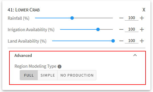
- Full:
The default behavior for most regions and model areas. When the Full option is selected, the region will be run through the PMP model and, when applicable, through the nonirrigated agricultural yield model.
- Simple:
In some cases, you may not want to make the assumptions that the full PMP model makes - in this case, the “simple” option prevents them from being modeled in the PMP formulation, and instead assumes a linear scaling of values based upon modifications in the input. Regions using the Simple model are unaffected by crop area constraints. See Simple Modeling and Linear Scaling for more information on how the region will be modeled when choosing this option. As of June 2021, using the Simple model will still run the nonirrigated model separately for crops and regions that have data available, but this behavior may change in the future.
- No Production:
Use this if you want to model the region as if it produced nothing over the model time period. In the San Francisco Bay Delta, for example, this can be useful for scenarios where an island floods and produces no agricultural output. An alternative is to model the region normally, but filter results in the output to remove the region, in case you want to assess results both with and without the region.
Warning
Note that these are high priority settings in that they take first precedence. A region set to No Production will not be affected by the crop modification settings you choose. Regions using the Simple model will interpret most inputs differently and will be unaffected by crop area constraints that would have otherwise affected the crops in the region. The team is discussing at this time whether crop area constraints values can be used in place of the land slider for crops they apply to.
Default Advanced Region Options#
In some cases, when choosing a region, one of the advanced region options may show up as chosen by default for that region. This occurs because some regions may have default modeling behaviors other than the full PMP model, based primarily on data availability. Regions with very small acreages of agriculture are very sensitive to fluctuations in inputs and regions with only one or two crop groups cannot be modeled with a PMP. In these cases, the region may show up with the Simple modeling option chosen by default. You may change these values, but note that it may make the results less reliable or result in an infeasible model run.
Warning
It is important to note that these default behaviors apply to the regions even if you do not choose them for modifications. If a region has a default modeling behavior and you do not create a region modification card for it, then the default behavior will apply.